Destination Earth Use Case
Forestry info page

Information
Company: Finnish Meteorological Institute
Destination Earth Use Case DE_370d_FMI
Use Case Overview
The forestry sector traditionally plays an important role for the national economy in the Nordic countries. Forests are a significant renewable natural resource and a key element of sustainable use. Therefore, management of forests has to include climate mitigation actions. Forestry operations depend not only on the tree condition but also largely on good trafficability of terrain and dirt roads in the forest, which is dependent on the current soil and weather conditions. The Harvester Seasons service for forestry, a web based service, developed by Finnish Meteorological Institute FMI, will provide a Destination Earth Use Case with new high-resolution maps for forest trafficability over Europe.

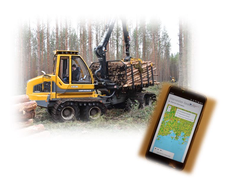
Figure 1: Forest operations are typically performed with so-called harvesters and forwarders, which require information on sufficient soil bearing capacity for those heavy machines. Service key user groups are forestry operators, forest owners, timber procurement, consultants, regulators; credit: Metsäteho
Figure 1: Forest operations are typically performed with so-called harvesters and forwarders, which require information on sufficient soil bearing capacity for those heavy machines. Service key user groups are forestry operators, forest owners, timber procurement, consultants, regulators; credit: Metsäteho
Forestry operations depend not only on the tree condition but also on good trafficability of terrain and dirt roads in the forest. Harvesting machines can weigh up to 20 tons and require stable ground to carry those machines while operating in the forest. Harvester Seasons is a service supporting the forestry sector on optimised operation-planning according to best soil bearing conditions. The service was originally developed as C3S use case under the Copernicus framework.
It has been operational since May 2020. Within the Destination Earth initiative, this service will be improved, and it will bring Destination Earth capabilities to users and stakeholders from the forestry sector.

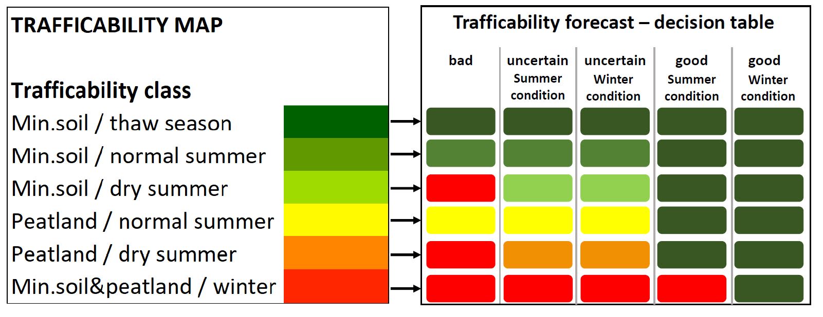
Figure 2: classification scheme for different soil types and under which dynamic soil and weather condition those are best trafficable with heavy machinery (index-based traffic light classification from green=good condition to red=bad condition)
Figure 2: classification scheme for different soil types and under which dynamic soil and weather condition those are best trafficable with heavy machinery (index-based traffic light classification from green=good condition to red=bad condition)
The best conditions for forest operations in Finland are typically found in the winter season, when the soil is frozen, snow covered and hard enough to carry heavy machinery. On soil with a high percentage of peatland, harvesting during the summer is only possible in dry conditions. With the effects of climate change shortening winter periods and increasing risks of forest fires during summer, it is necessary to better adapt the operation planning without losing productivity. Under the National Forest Strategy, Finland has decided on various actions and guidelines to ensure sustainable forest management.

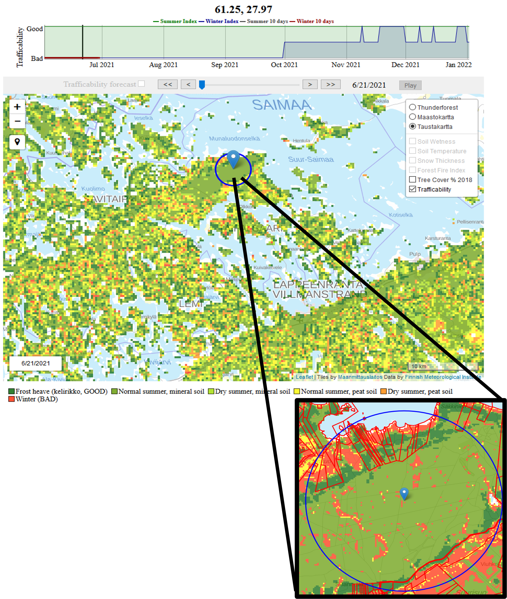
Figure 3: Map visualization of forest trafficability provided by the Harvester Seasons web service developed by FMI
Figure 3: Map visualization of forest trafficability provided by the Harvester Seasons web service developed by FMI
The Destination Earth use case on forestry intends to provide harvestability maps and information on climate change outlook for Europe, and extend potential new users to a European level. Machine learning (ML) models are being developed to downscale and bias-adjust several parameters including soil moisture, skin and soil temperatures, snow depth, and to produce a European harvesting trafficability maps. This relies on Destination Earth for computing and feature data sets. Currently the harvestability is available only in Finland. ML with gradient boosting will be used to extend the map to the rest of Europe. Machine learning algorithms combining ERA5, ERA5-Land, Copernicus Digital Elevation Model and ground-based measurements allow to downscale coarse model data on soil to a 1km resolution, especially required for forest operation planning. The main training dataset for this approach is 16m resolution static map on Finland soil classification provided by the Finnish forest center (Finnish “Kurjuukelpoisuus” map by Metsäkeskus). In addition to improving the key variables for harvestability analysis, we add new products to the service based on Destination Earth Digital Twin (DT) data.
From the DestinE Extremes DT, wind information will enable a prediction of potential forest damage caused by wind gusts. Such a highly resolved information helps forest operators initiate control checks on individual forest stands, which might have new fallen trees caused by windstorms, requiring actions on felling or clearing. Climate DT products will provide a climatic outlook on weather induced soil conditions. For the forestry sector, such information is helpful for future investments in forest areas. This would help harvesting operators to get an idea on potential productivity of forest stand locations as well as if and how operation planning can be more sustainable with respect to climate outlooks.
Within the Destination Earth project the Use Case on forestry will address directly the user needs. Having the Finnish company Metsäteho onboard allows to directly get in contact with the relevant stakeholders from the forestry sector. The biggest key players of the forestry sector are headquartered in Finland and networking partners within the Metsäteho client consortium. To shape the service development, those core users are involved in guiding the service development team with their insights on specific forestry needs.

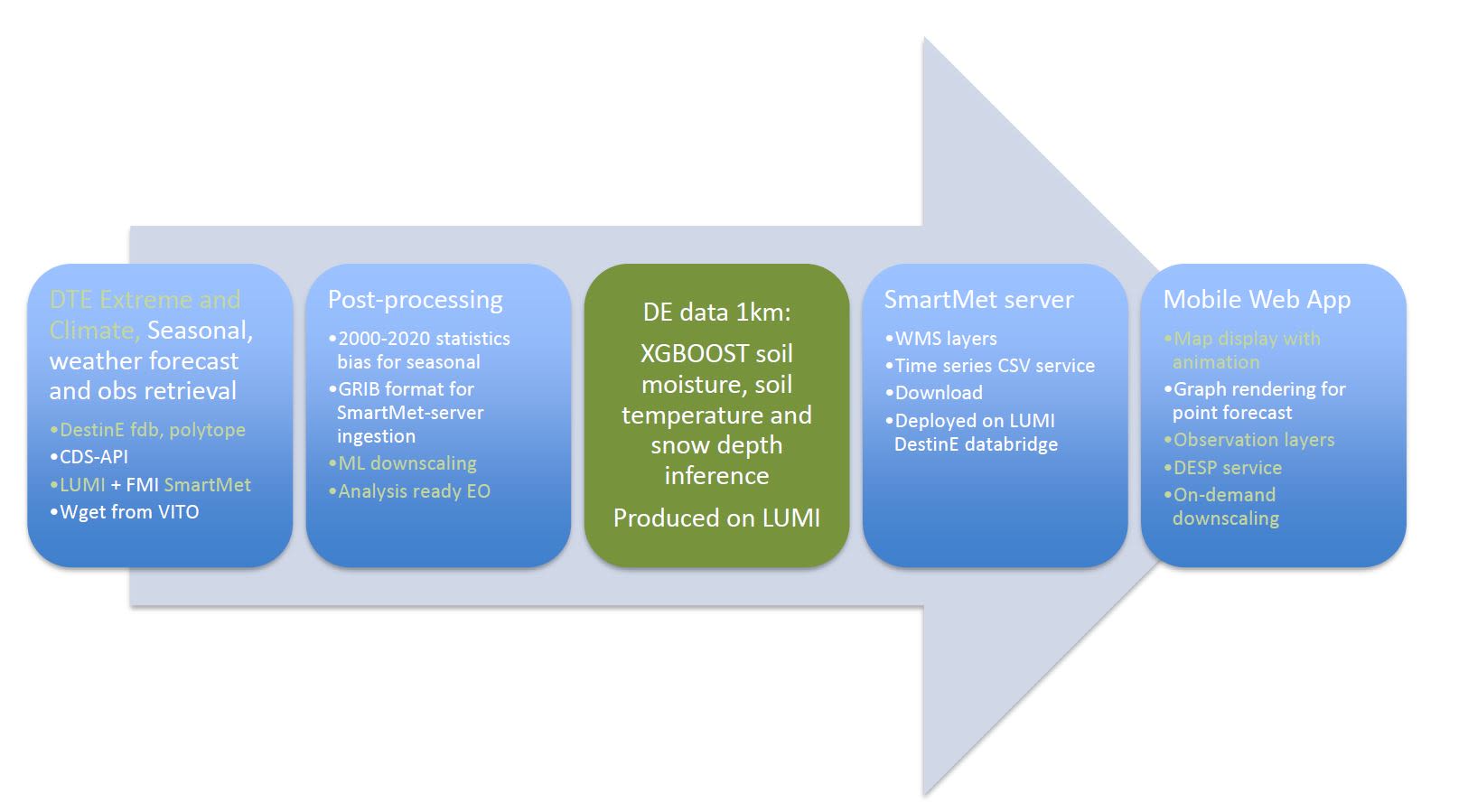
Figure 4: PERT chart for the Destination Earth Use Case on forestry: core of the new service implementation is a machine learning approach downscaling Destination Earth, seasonal, weather forecast and observations. FMI’s SmartMet data management server is deployed.
Figure 4: PERT chart for the Destination Earth Use Case on forestry: core of the new service implementation is a machine learning approach downscaling Destination Earth, seasonal, weather forecast and observations. FMI’s SmartMet data management server is deployed.
As a DestinE use case, FMI will implement parts of the service data management infrastructure, SmartMet, to Destination Earth capabilities. FMI will deploy an instance of the SmartMet server on the DestinE data bridge at LUMI, which is already involved in ECMWF’s digital twins. Complementing the data access and interoperability capabilities of the digital twin engine (DTE) within DestinE the SmartMet server allows a direct API access to the new datasets. This part of the use case will benefit not only the Harvester Season service development but also the Destination Earth initiative. By testing the infrastructure and data bridges, it plays an essential part in giving feedback to the Destination Earth Digital Twin Engine developers.
The Harvester Seasons service and use case on forestry will downstream Destination Earth products to the forestry sector in Europe. It will introduce those high-resolution products to users and help spread awareness on this European initiative and on the potential of those new service developments.
More information
- Read the first news article about this use case here https://stories.ecmwf.int/ecmwf-digital-twins-aid-sustainable-forestry-operations-under-new-destination-earth-use-case/index.html
- Harvester Seasons Service site: https://harvesterseasons.com
- Service updates on LinkedIn: https://fi.linkedin.com/showcase/harvester-seasons/