ECMWF digital twins aid sustainable forestry operations under new Destination Earth use case

Back to ECMWF - Destination Earth main page
The Finnish Meteorological Institute (FMI) and the European Centre for Medium-Range Weather Forecasts (ECMWF) have signed a new use case contract to apply Destination Earth’s digital twins' capabilities to improve forestry operations. The forestry use case seeks to improve the scope and performance of the existing Harvester Seasons application, which has been operational since May 2020 having been originally developed as a use case for the Copernicus Climate Change Service (C3S).
The Harvester Seasons application, developed in the framework of C3S and the Horizon 2020 EU programme’s E-shape project, already helps more than 200 users in Finland to better plan the use of heavy machinery on the complex Finnish forest terrains, often inaccessible due to snow, mud and the complicated orography. The app provides information on soil moisture, soil temperature and snow depths to inform the forestry industry on the suitable moments to enter individual parcels of the forest with heavy machinery. Harvester Seasons aims both at providing long-term information and short-term forecasts for more efficient planning.
More accurate data would allow, for example, the relocation of resources in the event of a large storm-hit forest area, where damaged trees need to be removed in a timely manner.

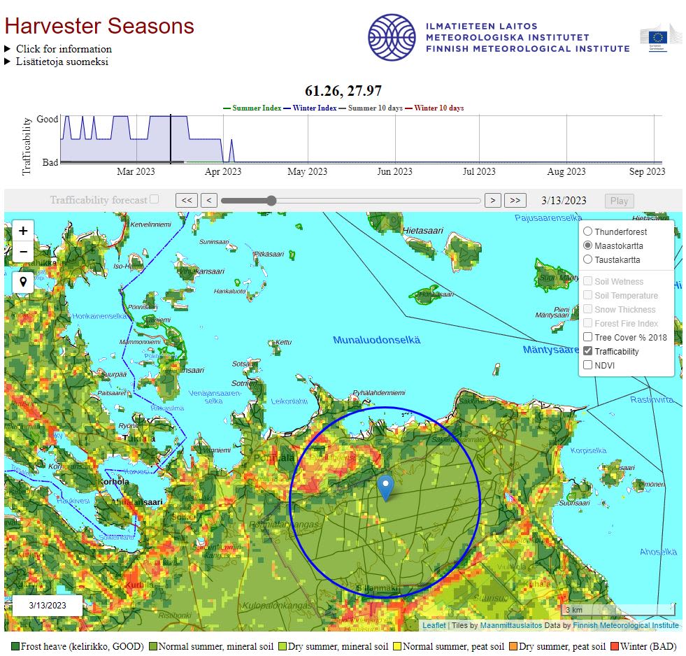
Using C3S and other Copernicus data the application provides a trafficability index, showing the areas where harvesting operations are possible. With DestinE, the level of detail will increase dramatically favouring better planning. Credit: Harverterseasons.com
Using C3S and other Copernicus data the application provides a trafficability index, showing the areas where harvesting operations are possible. With DestinE, the level of detail will increase dramatically favouring better planning. Credit: Harverterseasons.com
Destination Earth (DestinE) is the ambitious initiative of the European Union to create a highly accurate digital replica of the Earth system supporting the green transition and the EU’s digital strategy. ECMWF, as one of the entrusted entities to implement two of DestinE’s digital twins, has signed several use case contracts in order to demonstrate the capabilities of its digital twins on water risks management, urban heat islands, air quality, energy sector models and this forestry management use case. All five have already officially started.
Accompanying a sustainable forestry transition
Following a codesign strategy to ensure that the platform serves the needs of its users, ECMWF is in charge of creating the Weather-Induced Extremes Digital Twin (Extremes DT), the Climate Adaptation Digital Twin (Climate DT) and the Digital Twin Engine, the software infrastructure permitting the interaction between the different platforms involved in the project.
One of the main current challenges for FMI when it comes to forest trafficability information is to adapt the 2,8 to 100 km model information to Lidar-based soil classification information at 16 metres provided by Finland’s cadaster (Finnish “Kurjuukelpoisuus” map by Metsäkeskus). Using DestinE, FMI plans to apply machine learning combining data from ERA5, ERA5-Land, Copernicus Digital Elevation Model, Sentinel-1, Sentinel-3, Copernicus global land products and forest inventories in order to downscale the data on a European level to 1 km.

A view of Harvester Seasons trafficability map. Credit: Harvester Seasons
A view of Harvester Seasons trafficability map. Credit: Harvester Seasons
The current Harvester Seasons service takes C3S seasonal data from the Climate Data Store and FMI’s weather forecasts via the open-data SmartMet server. FMI plans to deploy an instance of the SmartMet server on the DestinE data bridge at LUMI, which is already involved in ECMWF’s digital twins, complementing the data access and interoperability capabilities of the digital twin engine within DestinE. These evolutions will improve the estimations of net ecosystem CO2 exchange (NEE) to evaluate the impact of forest harvesting and will provide the information on soil types, that are a major challenge for the forestry industry. FMI is also investigating to expand the product suite available today for users of Harvester Seasons, using the Climate DT to provide multi decadal projections and the Extremes DT to elaborate highly accurate predictions of forest damage potential using wind gusts data.
Finland aims to become climate neutral by 2035 but it has several challenges regarding the forestry industry, mainly due to the large number of private actors –up to half a million owners that utilise the landscape. FMI hopes that this solution will help the forestry industry to adapt and mitigate climate change by better understanding the impacts of its operations.
A European harvestability map
The service is currently available only for Finland. Entering DestinE FMI expects to cover all Europe by producing a European harvestability map based on machine learning with sub 100 m resolution information.
FMI has gathered a team of subcontractors, both from Finland. The forestry sector specialist Metsäheo will be in charge of leading the true user drive operations with workshops and surveys evaluating the application use and the needs of the sector. Spatineo is a leader in geospatial data services and will create an interactive interface using DestinE, based on the real users' requests and needs.
The application will initially operate on its current WEkEO cloud servers and the FMI cloud storage in Sodankylä. The machine learning operations will be performed on the EuroHPC system LUMI and FMI’s HPC unit in Sodankylä in order to demonstrate the interoperability of the system.
Destination Earth is a European Union funded initiative launched in 2022, with the aim to build a digital replica of the Earth system by 2030. The initiative is being jointly implemented by three entrusted entities: the European Centre for Medium-Range Weather Forecasts (ECMWF) responsible for the creation of the first two ‘digital twins’ and the ‘Digital Twin Engine’, the European Space Agency (ESA) responsible for building the ‘Core Service Platform’, and the European Organisation for the Exploitation of Meteorological Satellites (EUMETSAT), responsible for the creation of the ‘Data Lake’.
We acknowledge the EuroHPC Joint Undertaking for awarding this project strategic access to the EuroHPC supercomputers LUMI, hosted by CSC (Finland) and the LUMI consortium, Marenostrum5, hosted by BSC (Spain) Leonardo, hosted by Cineca (Italy) and MeluXina, hosted by LuxProvide (Luxembourg) through a EuroHPC Special Access call.
More information about Destination Earth is on the Destination Earth website and the EU Commission website.
For more information about ECMWF’s role visit ecmwf.int/DestinE
For any questions related to the role of ECMWF in Destination Earth, please use the following email links:
Press and Communications enquiries
Main photo: Joni Kuusisto, Unsplash