Destination Earth Adaptation Modelling Framework for Heat Stress Exposure

Back to ECMWF - Destination Earth main page
Destination Earth Use Case DE_372_Lot2_TECNALIA
TECNALIA 1 research organization will use Destination Earth’s Climate Change Adaptation digital twin (Climate DT) to develop an interactive tool supporting decision-makers in the assessment of different adaptation options for heat stress under projected climate change, with a special focus on public health management.
The tool will allow a better assessment of heat stress by considering different type of scenarios (land use changes, climate change scenarios) at different levels of regional granularity, identifying hotspot areas, high-risk populations, and evaluating different adaptation measures throughout the Basque Autonomous Community to reduce impacts in the Basque Region
Heat stress in context
According to the World Health Organization, the number of people exposed to heat waves increased by around 125 million between 2000 and 2016. In Europe, 70.000 people died as a result of the June-August events in 2003 and, in Spain, that summer produced a total of 6.534 deaths.
The most concerning is not only that these episodes confirm global warming trend, but also that projections suggest heat stress exposure will become worse in the future. If greenhouse gas emissions are not significantly curtailed, extreme temperatures and specifically heat waves will become more frequent, more intense and longer every year. Heat stress will cause devastating health impacts on growing urban and ageing populations, particularly threatening vulnerable populations (See also EEA report). A recent paper estimates over 70,000 deaths related to high temperatures during summer 2022 across Europe.
These impacts will depend on local factors such as exposure, vulnerability to climate-related stress and the implementation of efficient resilient policies. Well-prepared health systems and well-suited adaptation measures at different levels are essential to protect populations, limit the adverse impacts of heat and therefore reduce risks.

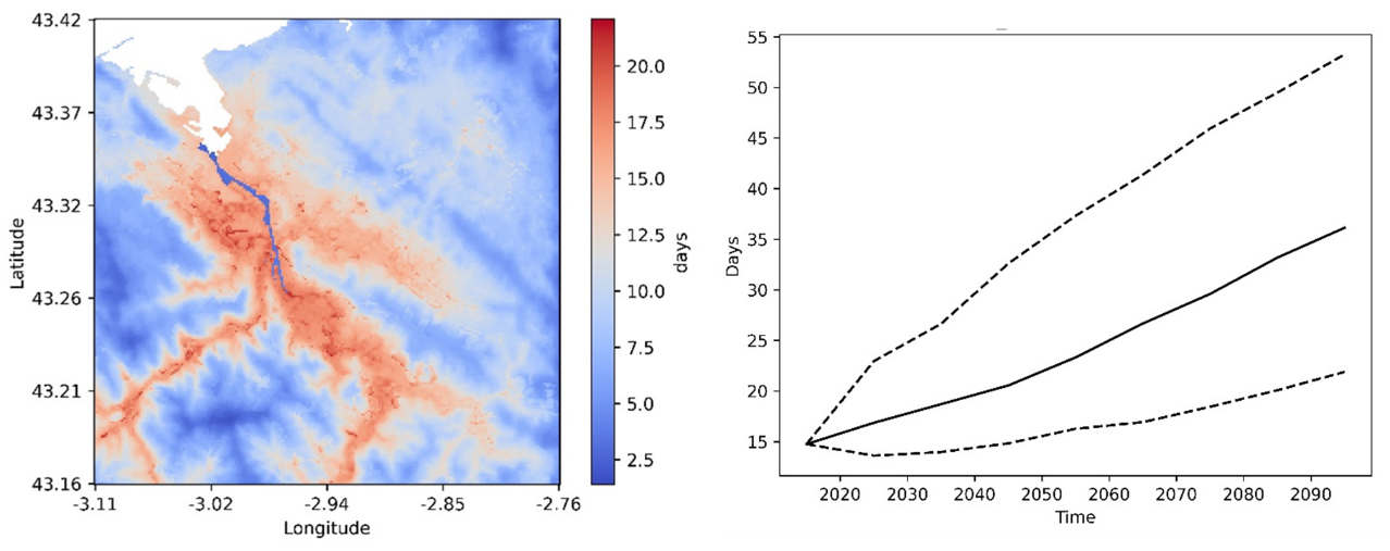
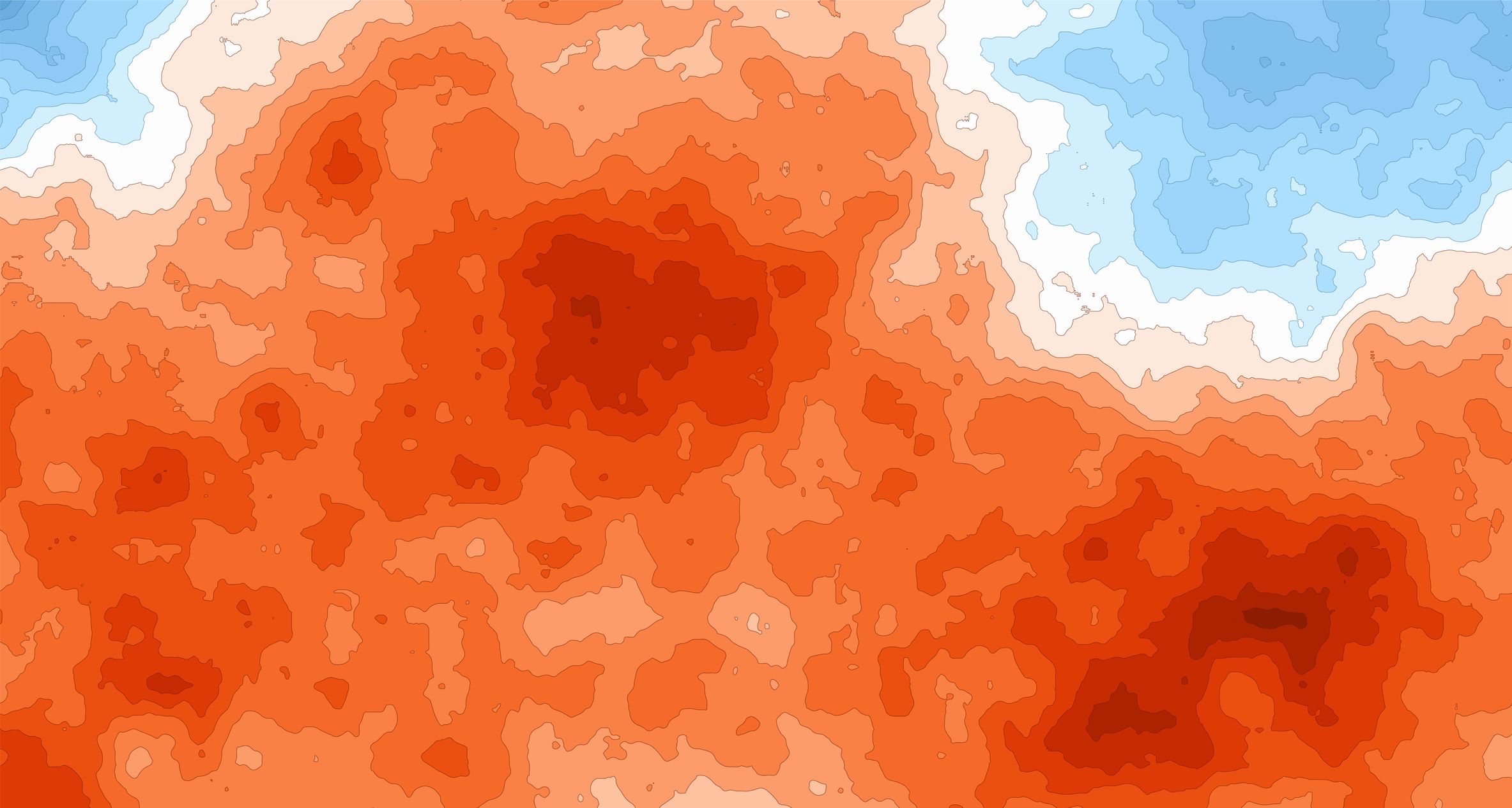
Figure 1. Showcase example of climate information at 100m spatial resolution for Bilbao. The number of days in which temperatures exceed 30°C are shown (left), together with its projected evolution averaged over the city towards the future in a Current Policies scenario (as defined by the IPCC), including model uncertainty (right).
A trustworthy and accurate operational system using DestinE’s Climate Adaptation Digital Twin
Current information and simulation models about heat exposure are limited in time and space due to the high computational costs, making it sometimes too complex for stakeholders to have accurate assessment of heat stress. These hurdles to obtain and interpret heat stress data lead to difficulties for stakeholders to implement effective adaptation measures. The architecture of DestinE provides a unique opportunity to develop an operational environment in which different but interconnected tools provide trustworthy and accurate guidance and advice to decision-makers in the process of designing adaptation measures.
The proposed modelling framework is ‘operational,’ because the Climate DT will develop a dynamic system in which any change in any part of that system will automatically update other parts. The tools will automatically link through a unified entry point to the latest and up-to-date input datasets that will all be available on the Destination Earth’s Data Lake (DEDL).
Technical solution
Based on the data provided by the DEDL, TECNALIA and VITO will develop an integrated set of components based on data-driven statistical models, physically based simulations, cost-impact analysis of adaptation options and algorithms. The proposed approach includes three key components: hazard modelling, health impact modelling and a web application. Adaptation measures can be considered as an intermediate, common component between the hazard and health impact modelling since they will guide both aspects. The next figure describes the data workflow and how the different components are connected.

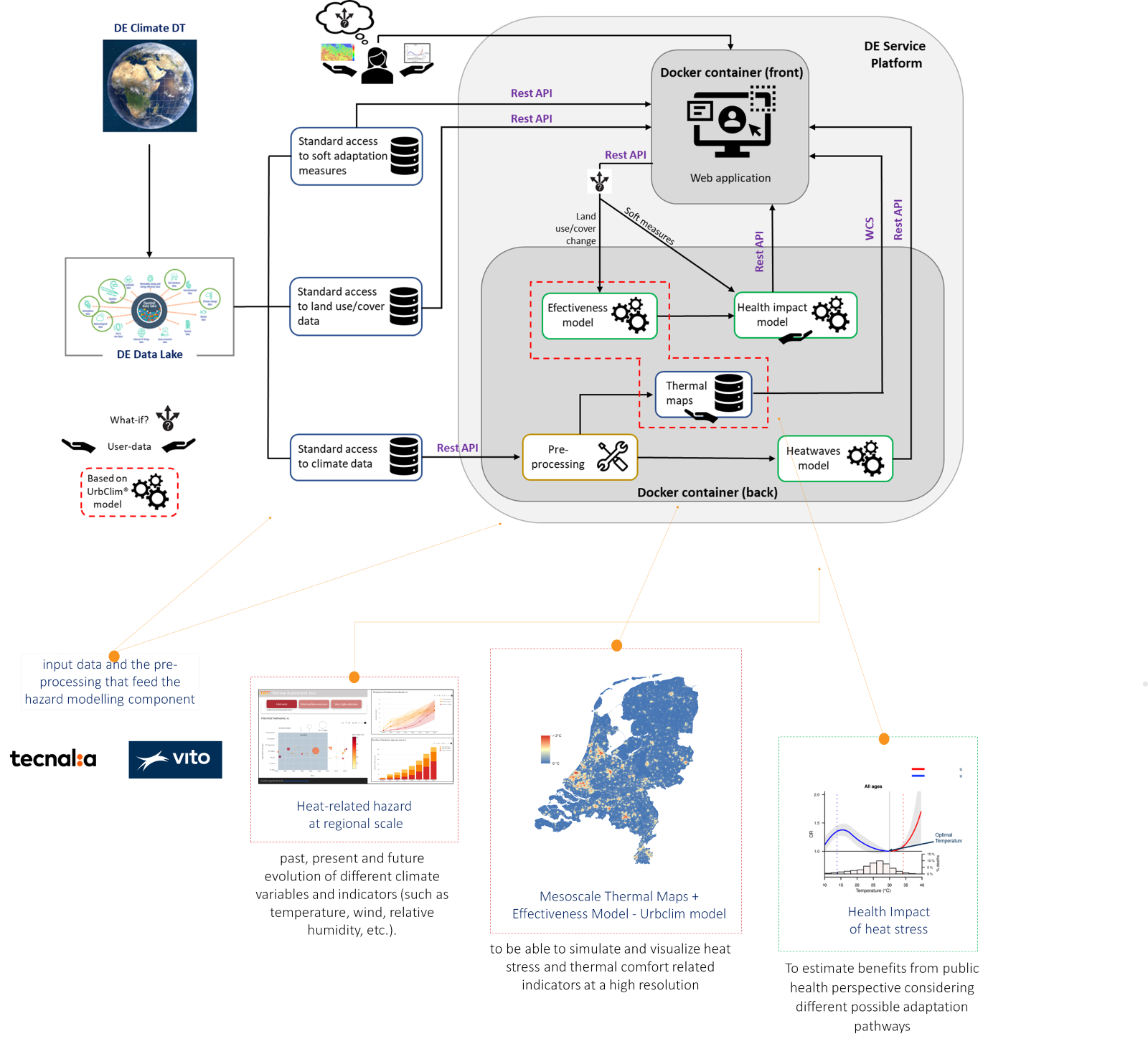
Figure 2. Initial data workflow and main components
- Regional heat stress: Past, present and future evolution of heatwaves in Basque Country considering their spatial extent to assesses and visualise the regional behavior of heatwaves by ingesting data from the Climate DT through the DEDL.
- High-resolution (100m) urban heat maps for the Basque Country based on the UrbCLIM® model nested within large-scale atmospheric outputs provided by state-of-the-art global climate models from DestinE Climate DT assessing air temperature and thermal comfort indicators to underpin and motivate territorial interventions.
- Health Impact model: assess and visualise the impacts on health in terms of epidemiologic indicators and values (morbidity, mortality, etc.) to better support the design of measures.
- Web-based graphical interface providing easy and accessible viewers and dashboards to support decision-makers in the assessment of adaptation options for heat stress adaptation under different climate change scenarios.
Contribution to the Adaptation modelling framework
This contract also aims to contribute to the development of a generic framework for adaptation modelling under climate change in the context of DestinE following the DG CLIMA study on Adaptation Modelling, which considers gathering information from stakeholders and the development of a demonstrator for better-informed policy and decision making. The general framework will be leaded by Deltares through the use case focused on flood risk management.
Both contracts aim to develop this generic adaptation modelling framework designed to empower end-users in harnessing digital twin technology and to demonstrate its implementation thought highly accurate and on-demand climate modelling capability for appraising adaptation options in two different domains: flood risk management with focus on prevention and mitigation, and heat stress exposure, with a focus on public health management.
A team of experts gathered to demonstrate the value of the Climate DT
In order to achieve the ambitious objectives of this use case TECNALIA has set up a consortium composed of members of its Climate Change Adaptation team Urban Transformation Lab of TECNALIA with vast experience developing projects for regional and local authorities related to climate resilience and members from VITO Climate Impacts group (CLIM), complemented by members from the business unit of VITO “Environmental Modelling (VITO-RMA)” with expertise in quantitative assessment of climate related impacts and has recently been contracted by ECMWF to develop a use case to tackle urban heat islands.
* TECNALIA is a member of the Basque Research and Technology Alliance
Destination Earth is a European Union funded initiative launched in 2022, with the aim to build a digital replica of the Earth system by 2030. The initiative is being jointly implemented by three entrusted entities: the European Centre for Medium-Range Weather Forecasts (ECMWF) responsible for the creation of the first two ‘digital twins’ and the ‘Digital Twin Engine’, the European Space Agency (ESA) responsible for building the ‘Core Service Platform’, and the European Organisation for the Exploitation of Meteorological Satellites (EUMETSAT), responsible for the creation of the ‘Data Lake’.
More information about Destination Earth on the EU Commission website
More information about Destination Earth on the EU Commission website
For more information about ECMWF’s role visit ecmwf.int/DestinE