Destination Earth Use Case
Disaster Risk Mitigation & Climate Adaptation


PROJECT BACKGROUND
Compound Flooding – A Complex Issue

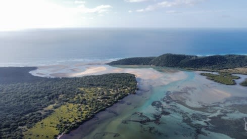
Figure 1.1 Areas where rivers meet the sea, like here, have potential risk of compound flooding
Figure 1.1 Areas where rivers meet the sea, like here, have potential risk of compound flooding
Climate change will result in sea level rise and changes in environmental conditions, such as changing rainfall patterns or marine physical conditions. At deltas around the world, where the river meets the sea, extreme events such as hurricanes may result in a phenomenon known as compound flooding. Compound flooding refers to an event in which two or more flooding sources occurs simultaneously or in quick-succession, causing an amplified event that results in greater impacts. This phenomena also poses unique challenges owing to the multitude of variables that contribute towards the hazard such as tides, surge, waves, river discharge, precipitation and extreme events such as cyclones.
To support better forecasting and disaster mitigation, higher resolution information is required to deliver information in a timely manner. A unique opportunity is provided by DestinE in that regard, as higher-resolution meteorological forecasts and climate projections can contribute towards keeping people safe from flooding, now and for the future.
Digital Twin for Disaster Risk Reduction and Climate Adaptation
Deltares, together with its partners KNMI, Tecnalia and 510 Red Cross, are working on setting up a digital twin that will support disaster risk reduction and climate adaptation. A generic, globally-applicable modelling framework using open-source model components will be applied, and where needed, replaced or refined further using local models, thus, applying a “global to local” approach. A total of five case study areas have been selected: Basque Country, United Kingdom, Philippines, La Reunion and the Dutch Caribbean Islands (BES Islands). The diversity in environmental conditions and user needs across the case studies will allow the team to demonstrate the applicability of the service. For each case study area, an end-user is identified, who will provide iterative feedback to determine case-specific requirements. The system will ideally ingest high-resolution meteorological forecasts and climate simulations, forming the input for regional coastal or inland models to provide boundary conditions for local modelling. A generic, globally applicable framework will be created using open-source model components from Deltares that could be replaced by existing user-owned models. To address climate adaptation challenges, the system will facilitate the exploration of future pathways for coastal adaptation. The results generated within this contract for each of the case study areas will be disseminated to users via various services such as the APIs, web mapping services or (S)FTP, depending on users’ preference. When available, the datasets can also be made available via the Destination Earth Core Service Platform (DESP) and the Destination Earth Data Lake (DEDL).
The first version of the service will build upon locally used weather forecasts (ECMWF, MeteoFrance, UK MetOffice, KNMI), existing climate projections (Copernicus, CMIP, CORDEX, CP-RCMs), wave datasets (ERA5/WaveWatch III) and discharge datasets (GLOFAS, EFAS). The currently available forcing data, such as ECMWF High Resolution, has spatial resolutions of up to 9km. However, from past work, we know that modelling the complex processes of compound flooding requires higher-resolution input data in order to generate relatively higher resolution flood maps of up to 200m. When available, Destination Earth and their contractors will be able to deliver forcing data of up to 2km in spatial resolution, which will potentially improve the accuracy and resolution of the final flood maps. We expect to integrate higher resolution (in space and time) successors of the abovementioned datasets available with regular updates through Destination Earth in the Tier2 dataset. Hereto an operational pipeline between the developed system and Destination Earth will be developed using the REST API interface and other workflow functionalities. For validation of the model outputs observed flood extent maps from the archive of the Copernicus Emergency Management Service (CEMS) will be used.

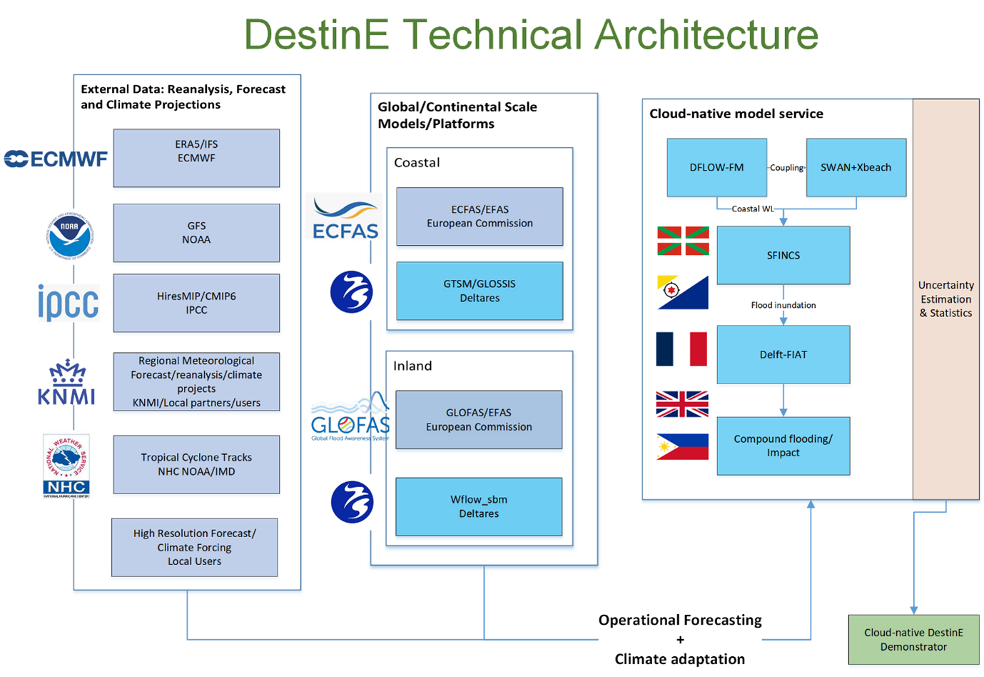
Figure 1.2: Schematic of DestinE Technical Architecture proposed within this project
Figure 1.2: Schematic of DestinE Technical Architecture proposed within this project
What has happened and what can you look forward to?
Thus far, we have collected the first user requirements in a workshop held at the end of March. Each user presented the unique challenges they faced, and the first set of requirements were collected to feed directly into the technical design. For all the users involved, using higher resolution data for forecasting is a common interest. In addition, users would like to validate or compare the results from this project with historical extreme events where data was also captured, in order to assess the suitability of the digital twin outputs for their various needs.
By end of August, we will be focused on getting the generic model train (workflow) up and running, with first results expected by then. The outputs of the compound flood model are maximum water levels with a resolution of 200m. With higher resolution Digital Elevation Models (DEM), the data can be translated to flood depths at much higher resolutions. With globally available DEMs, this can be up to 30m, while in-situ elevation models with higher resolution will facilitate higher resolution flood depths.
A progress workshop with all the users will be organized once the first datasets are developed. You can expect periodic updates as we progress through the project and sharing of first results. For further information on each case study, click the following links to follow the journey with each user!

Figure 1.3: Timeline for the duration of the project
Figure 1.3: Timeline for the duration of the project
CASE STUDY: BASQUE COUNTRY
Basque Country

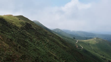
Figure 2.1 Basque Country has varying and steep topographies, resulting in frequent flash flood events during extreme rainfall.
Figure 2.1 Basque Country has varying and steep topographies, resulting in frequent flash flood events during extreme rainfall.
An autonomous community located in the northern part of Spain and the southwestern part of France, Basque Country is known for its diverse culture and landscapes. Like many regions around the world, Basque Country also faces challenges from natural hazards such as flooding, erosion and landslides. Under climate change, these hazards are likely to be exacerbated, resulting in increasing impacts as well.

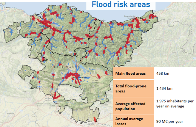
Figure 2.2: Areas with risk of flooding in the Basque Country
Figure 2.2: Areas with risk of flooding in the Basque Country
Owing to the region’s topography and steep relief, this makes the region prone to flash floods during periods of heavy precipitation, and in some cases, the response time can be on the order of less than 1 hour. In recent years, there have been several severe flood events that have caused infrastructural and economic damage in Basque Country, such as the November 2021 floods. Urbanised areas are especially vulnerable owing to the dense urban planning and impact on populations and infrastructures. The Basque Water Agency (URA - Uraren Euskal Agentzia) is responsible for flood mitigation, protection and preparedness within the region, who are also the end users within this project for the Basque Country case study. They focus on four main pillars in their flood management strategy: Prevention, Protection, Preparation and Recovery & Evaluation.
The User


The Basque Water Agency (URA) is an entity of the Basque Government tasked with the role of carrying out the water policy in Basque Country, including management of water quantity, quality and safety. Due to the long history of flood occurrence in the region, one of the strategies URA undertakes is to promote co-existence with floods, and where needed, flood mitigation measures such as urban planning and protection.
Current forecasting infrastructures
Currently, Basque Country has two systems in-place to support timely delivery of actionable information.
SAIH (Automatic Hydrological Information System): A network of meteorological and hydrological data collected from a network of more than 130 measurement stations. Several agencies contribute to this system, resulting in a robust collection of monitoring data.
UHATE (Hydrological Prediction and Alert System): A real-time forecasting information system that provides emergency services with information on the probability of hydrological flows to support rapid decision-making. The hydrological forecast is based on real-time data and meteorological forecast, based on a dense monitoring network of over 220 stations and buoys.
In the event of a flood event, a close collaboration between the Basque Water Agency, Euskalmet (Meteorological office of Basque Country) and Civil Protection collaborate and take part on the emergency committees for disaster preparedness and evacuation.
Contribution to the Disaster Risk Mitigation & Climate Adaptation Use Case
On the 17th March 2023, the user kick-off workshop was held at the Deltares office in Delft. The main goal of the meeting was to understand the individual users’ needs and to set a draft scope for the individual case study. In the case of Basque Country, decision-making currently relies heavily on expert judgement and much less on models or forecasts. The curiosity remains if higher resolution data made available within Destination Earth could potentially contribute to improved forecasting. In addition, compound flooding was identified to be much less of an issue. Instead, other types of flooding are a concern here, which are namely pluvial and fluvial. Pluvial flooding occurs when when the drainage capacity of the infrastructure in place is not sufficient or when the amount of rainfall exceeds the capacity of water to infiltrate through the ground. Fluvial flooding occurs when rivers overflow from excessive water, resulting in flooding in the immediate area. However, identifying surge components might become more important with sea level rise. The generic model workflow for both hydrological and coastal hydrodynamics modelling can then be applied for this region. When higher resolution meteorological data is made available within Destination Earth, the higher resolution results for both disaster preparedness (forecasting) and climate adaptation can be assessed for its suitability in the region.
Partners


Tecnalia is the largest center of applied research and technological development in Spain and a member of the Basque Research and Technology Alliance, focusing on the use of technology for societal improvement. Tecnalia regularly works with URA on the development and improvement of the current Delft-FEWS forecasting system for the Basque Country. Within this project, Technalia will support the data exchange and user interaction with URA.
CASE STUDY: LA REUNION

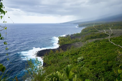
Figure 3.1 La Réunion's coastline, which is highly exposed to swells that may contribute to higher water levels and increasing flood risk
Figure 3.1 La Réunion's coastline, which is highly exposed to swells that may contribute to higher water levels and increasing flood risk
La Reunion
The island of La Réunion is a French overseas department situated in the western Indian Ocean and home to the highest peaks in the Indian Ocean. Due to its geographical location and topography, the island experiences several natural hazards such as cyclones, landslides, and coastal and inland flooding. The island holds records for some of the most extreme rainfall events as a result of these cyclones. Some of the most damaging events included Cyclone Denise (1966), Gaméde (2007), Fakir (2018) and Berguitta (2018). During a cyclone, the low-pressure system generates extreme precipitation, storm surge and swells. Combined with its mountainous terrain and exposed coastline, the island is susceptible to flash floods in low-lying areas from both inland and coastal compartments. Floods have socio-economic consequences for the island, such as population safety and damages to businesses, assets and infrastructure.
To overcome compound flood hazards, the island has implemented various measures including early warning systems, land use planning and infrastructure improvements. However, the unique geographical characteristics of La Réunion presents ongoing challenges in managing these hazards and protecting vulnerable communities. Currently, emphasis is placed on ensuring a good and reliable forecasting system is in-place. In this respect, DEAL (Direction de l'Environnement de l'Aménagement et du Logement de La Réunion) is the primary agency responsible for flood forecasting and management on the island, and is the La Réunion user within the DE370A_Deltares project.
The User


DEAL is the department of environment, planning and housing of La Réunion. In particular, the Cellule de Veille Hydrologique (CVH – Hydrological Watch Cell) is responsible for flood forecasting, flood vigilance, evacuation and mitigation. With a total of 8 agents stationed on the island and 29 monitoring stations for 17 sub-catchments, DEAL is primarily interested in robust forecasting results to support rapid evacuation or intervention if needed.
Current forecasting infrastructures
managed by the CVH team in DEAL. These are:
- Génie Rural Prevision: consisting of a global hydrological model with flow rate assimilation
At the moment, another forecasting system is being developed by Surface Libre for higher detail modelling in 3 sub-catchments, featuring a distributed hydrological modelling routine with local hydraulic modelling for flood forecasting, as well as containing a library of flood maps for different scenarios.
Contribution to the Disaster Risk Mitigation & Climate Adaptation Use Case
On the 17th March 2023, the user kick-off workshop was held at the Deltares office in Delft. The main goal of the meeting was to understand the individual users’ needs and to set a draft scope for the individual case studies. For the case of La Réunion, the main knowledge gaps highlighted by DEAL were for the various coastal hazards such as compound flooding from overflow and surge and cyclonic swells.
Their main requirements identified were for higher resolution data to support evacuation procedures and providing sufficient certainty of at least 1 day before a predicted event. To meet their needs, a wave and flow model will be set up for the entire island, while the west, north and eastern parts of the island can be more focused on riverine and urban areas.
DEAL is responsible for issuing flood warnings and based on the proposed flood maps they could provide more detailed and location specific flood warnings that help improve emergency response. By using consistent datasets for the coastal and inland part of the Island more accurate assessment can be made of the impact of compound events than is currently the case.
Partners


Surface Libre is a company specialising in consultancy services to provide training and support for hydrological and hydrodynamic modelling. They are currently developing the 3rd real-time modelling system for La Réunion. Owing to their experience working in La Réunion and with DEAL, Surface Libre will be helping to distil and translate user requirements within this project.
Humber estuary, UK


Figure 4.1 The Humber Estuary, an area where compound flooding is a concern due to its potential damages on local communities and industries.
Figure 4.1 The Humber Estuary, an area where compound flooding is a concern due to its potential damages on local communities and industries.
In the United Kingdom (UK), the main drivers of flood risk are rainfall, tides and storm surges, while secondary risk drivers are from wave overtopping and wave setup. Currently, flood risk management is well developed, given the many flood defenses and flood forecasting capabilities. However, climate change brings about uncertainties in frequency and intensity changes. As such, compound flood events may happen more frequently in deltaic or estuarine areas. Due to the complex interaction between riverine and coastal components, compound flooding is more difficult to model, making estuaries especially interesting.
With this in mind, the Humber area is an interesting case study area to explore within this project. The Humber Estuary is located in the eastern part of England. Its low-lying nature, along with its vast catchment area, makes it highly vulnerable to flooding. It is an estuary with a high population density, combined with industrial and agricultural activities. Owing to its dense urban planning, flood risk is high in this area due to the broad potential impacts, with the notable floods of December 2013. Within the Humber area, a mix of hard and soft measures are presently implemented to reduce the risk of coastal flooding and erosion.
Within the UK, the Environment Agency is tasked with flood risk management. In this project, the Environment Agency is the end users for the Humber Estuary case study.
The User


The Environment Agency is the government agency primarily responsible for flood risk management in England. Their flood and coastal risk management services include: 1) Flood incident management for forecasting, warning and response 2) Asset management for maintaining, operating, improving, building or creating assets 3) Strategy and investments for understanding risk, planning and defining investment needs, and detailed design and options appraisal. The Environment Agency and Deltares has a long working relationship, as the UK was one of the first countries where a Delft-FEWS forecasting system was implemented.
Current forecasting infrastructures
A fluvial forecasting system and coastal look-up model data has been setup. The model used for the fluvial forecast is the Humber 1D Flood Modeller Pro (FMP) model constructed by the Environment Agency. Thresholds for acceptable water levels are determined beforehand. When values are exceeded during the forecast, these trigger action protocols such as mitigation or evacuation. To properly support evacuation measures, an accurate lead time of 3 days is required.
Contribution to the Disaster Risk Mitigation & Climate Adaptation Use Case
Inundation maps are currently produced for different scenarios in forecasting mode for the Humber estuary. However, the main challenge is that the interaction between fluvial and coastal compartments are not fully captured in the forecasts due to their complexity. Several main requirements have been identified to address this, which will be tackled within this project:
- Currently the Humber model is a 2-dimensional model and is able to model complex processes, however, it is not yet suited for forecasting mode due to its runtime.
- Climate change poses a significant threat to the human activities and population safety within the Humber area. The Environment Agency is currently involved in the Humber2100+ project,which focuses on creating strategies to deal with future risks that the Humber Area will experience in the next 100 years. Thus, results from both forecasting extremes as well as modelling future flood depths based on different climate scenarios are important to the Environment Agency.
- The certainty of the December 2013 tidal surge event could only be established 3 days prior to the event. Improving the forecast certainty and lead times can lead to better response in the future, and is an important aspect to tackle by the Environment Agency.
Case Study: Dutch Caribbean Islands (BES)

Figure 5.1 Small island states like the BES islands have highly exposed coastlines. Being located on the hurricane belt significantly increases their coastal flood risk.
Figure 5.1 Small island states like the BES islands have highly exposed coastlines. Being located on the hurricane belt significantly increases their coastal flood risk.
The Dutch Caribbean Islands – Bonaire, Sint Eustatius, Saba
The islands of Bonaire, Sint Eustatius and Saba (BES islands) are a group of islands that are part of the Caribbean Netherlands, with a special municipality status. These islands are famous for their unique landscapes and coastal ecosystems. However, they are also subject to various natural hazards that pose serious risks to the environment, infrastructure and the safety of the local populations.
A significant natural hazard that these islands experience are hurricanes. Located in the hurricane belt, the BES islands are vulnerable to tropical cyclones that form in the Atlantic Ocean during the hurricane season between June to November. Hurricanes are a destructive force of nature, bringing in heavy rainfall, high wind speeds, storm surges, coastal and inland flooding. These hazards can damage critical infrastructures and threaten the safety and well-being of local communities. As small islands with highly exposed coastlines, other coastal hazards such as erosion and sea level rise can result in loss of beaches and coastal habitats, as well as threaten freshwater resources due to salinization. The low-lying nature of the island makes them more susceptible to such hazards. Under climate change, these islands remain more vulnerable than ever, and will require adaptation measures to protect the coastal environment and communities.
As the BES islands hold a special municipality status, the Water Management Centre of the Netherlands (WMCN) is tasked with the responsibility of providing timely hydro-meteorological information for these group of islands. Within this project, WMCN is an end-user that interfaces with the local BES authorities. Currently, there are no existing hydrological or flood forecasting infrastructures in-place.
The User


The Water Management Centre of the Netherlands (WMCN – Watermanagementcentrum Nederland) within Rijkswaterstaat (agency under the Dutch Ministry of Infrastructure and Environment) is the knowledge and information centre for the Dutch water system. Dutch water managers work at the regional and national level within the centre and aims to contribute towards uniform and optimal management of the Dutch water system. By collaborating together with the Dutch Meteorological Institute (KNMI), regional water boards, provinces, security regions and knowledge institutes, WMCN leverages this platform to be able to perform its duties to the best of their abilities and available knowledge.
Contribution to the Disaster Risk Mitigation & Climate Adaptation Use Case
Aside from sitting in the hurricane belt, the BES islands will continue to be more vulnerable in the future under the impacts of climate change, such as increased frequency and intensity of extreme events and with sea level rise. KNMI currently has a hazard platform for weather, aviation and seismology for the BES islands. A generic model workflow for hydrology and coastal hydrodynamics will be applied under forecasting mode. Future climate scenarios will also be explored to further understand the adaptation potential. The results produced will be ingested into the KNMI hazard platform for the duration of this project.

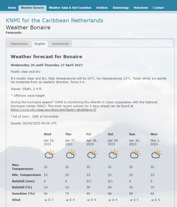
Figure 5.2 KNMI's hazard platform for the Caribbean Netherlands (BES islands)
Figure 5.2 KNMI's hazard platform for the Caribbean Netherlands (BES islands)
Partners

The Royal Netherlands Meteorological Institute (KNMI) is the national research and information centre for weather, seismology, climate and climate change in The Netherlands. With its long tradition in operational and scientific activities, the climate research undertaken at KNMI aims at observing, understanding and predicting changes in the climate system. KNMI offers products and services that contribute to the safety, accessibility, sustainability and prosperity of the Netherlands. Within this project, KNMI will be responsible for the data interface to the BES islands. KNMI, WMCN and Deltares have a long and strong history of collaboration on flood forecasting, river management and climate adaptation for the Netherlands.
Case Study: Philippines

The Philippines is an archipelagic nation consisting of over 7000 islands, resulting in a highly exposed coastline. The Philippines has an extensive coastline of over 36,000 km, as such, coastal flooding is also a prominent natural hazard in the country. Rising sea levels, storm surges and high tides pose risks to coastal communities. Human practices such as groundwater extraction, land reclamation and rapid urbanisation have all contributed to increasing both the risk and vulnerability of many coastal communities. Located along the Pacific Typhoon Belt, The Philippines experiences an average of 20 typhoons per year. In such an extreme event, heavy precipitation, intense wind, storm surge and landslides result in devastating damages and loss of lives. Past occurrences such as Typhoon Haiyan (2013) Typhoon Melor (2015) and Typhoon Mangkhut (2018) resulted in catastrophic damages to infrastructure, agriculture and communities.
The risk of flooding in the Philippines will likely continue and potentially increase in severity and frequency with climate change. Early Warning Systems are an important tool for Forecast-based Financing (FBF), a mechanism that releases humanitarian funding based on forecast information. Using data-driven and physics-informed modelling approaches, the data modelling arm of the Red Cross (510) uses impact-based forecasting to support the Philippines Red Cross in their humanitarian efforts. As such, 510 is the main user within this project.
The User


510 is an initiative of the Dutch Red Cross and is the data modelling centre to support various global Red Cross activities. 510 undertakes a strong data-centered approach and utilises state-of-the-art technology to improve humanitarian aid access and disaster risk mitigation globally, such as machine learning and block-chain technology.
Current forecasting infrastructures
The Red Cross currently has several EWS in-place:
- Riverine flood EWS
- Tropical cyclone risk EWS
- Storm surge flood risk EWS
Their particular interest lies in the improvement of their impact-based forecasts for tropical cyclones in this project by including improved and dynamic modelling components in the Tropical cyclone risk EWS. In addition they currently use the riverine forecasts from GLOFAS that can in the current project potentially be compared or replaced with higher resolution hydrological forecasts from DE. Currently, large potential impacts forecasted will trigger an Early Action Protocol (EAP). The EAP supports the implementation of timely and effective anticipatory actions before a cyclone makes landfall, triggering the Forecast Based Financing (FBF). When triggered, the FBF releases funds for anticipatory actions prior to landfall to reduce the impact of the cyclone. The design of an appropriate EAP trigger is, therefore, highly dependent on the quality of the forecasts of high winds, strong rainfall intensities and potential storm surges and waves associated with typhoons. The impact-based forecast is currently modelled using machine learning methods, combining exposure and vulnerability with hazards such as wind speeds, rainfall, typhoon tracks and other impact data.
Contribution to the Disaster Risk Mitigation & Climate Adaptation Use Case
Prior to landfall, the rapid intensification of tropical cyclones makes it difficult to accurately forecast with a 3 day lead time. In addition, some global data products have been found to be unsuitable for accurate impact-based forecasting. The goal is to improve the forecasting capabilities of the various hydrodynamic and/or hydrological models, such that the EAP can be triggered with more accurate impact forecasts to support timely and appropriate humanitarian action.