Combatting soil loss
in Italy
Humanity’s success is rooted in the soil beneath our feet. Healthy soil was fundamental to the rise of ancient cultures, from the Maya civilisation to the Roman Empire, providing food in abundance since the arrival of agriculture over 12 000 years ago.
Yet soil erosion due to poor management and climatic factors may have contributed to the downfall of these societies. Now with the twin pressures of a growing global population and climate change, soil loss is once again threatening the security of food supplies in Europe and beyond.
Fondazione Centro Euro-Mediterraneo sui Cambiamenti Climatici (CMCC) is a research network based in Italy, that carries out quantitative analysis of Earth’s future to understand how societies can adapt to climate change and mitigate its impacts. Using data and tools available in the Copernicus Climate Change Service (C3S) Climate Data Store (CDS), CMCC created a powerful new application to investigate the current extent of soil loss in Italy due to water erosion and look at possible future developments, under climate change scenarios.
In making this application, researchers at CMCC leveraged the added value of the temporal and spatial resolution of the C3S datasets. The application proves helpful for landscape management users, as well as policymakers who wish to lower economic and physical risks related to soil erosion and can be extended to many global regions.
“The added value of using the C3S Climate Data Store is that the data are not only of suitable temporal and spatial resolution, but also that the comparison among the data provides us with information about the uncertainties.”
As the ‘skin of the Earth’, soil forms the interface between Earth’s rocky interior and the organic life at the surface. Not only is it a habitat of its own, it also helps to regulate others. Organisms and geological processes constantly recycle minerals, nutrients and water in the soil, maintaining the balance of soil production and erosion to keep it healthy.
Soil faces many threats, including water erosion, contamination, degradation and loss to organic material, as well as declining biodiversity, salinisation, intensive farming and natural hazards such as flooding and landslides.


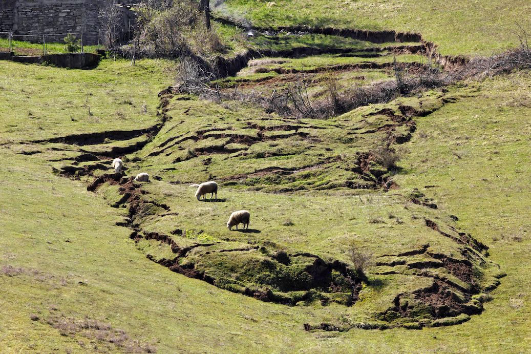
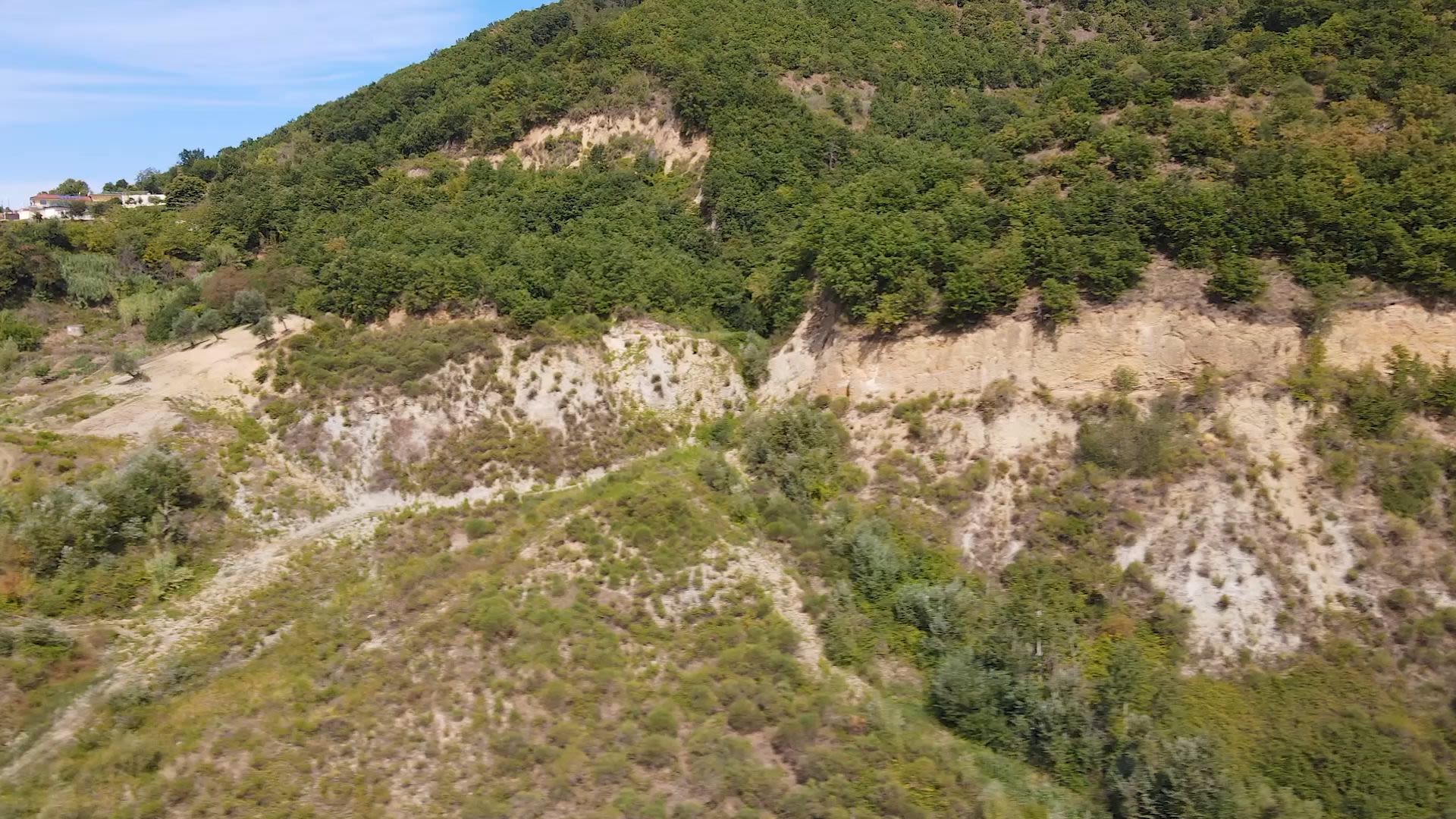
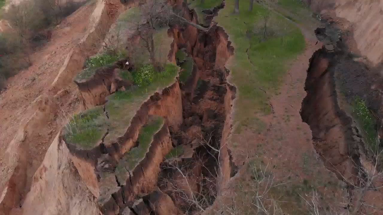
Heavy rains, melting snow or irrigation can lift the top layer of soil, transport it and deposit it elsewhere. When the soil erosion rate is higher than the formation rate, the layer of productive soil grows thinner. Over many years, this can completely degrade soil resources and reduce the potential of the land to be used for productive agriculture. Not only does this threaten food production, it can also lead to the spread of pathogens and infectious diseases.

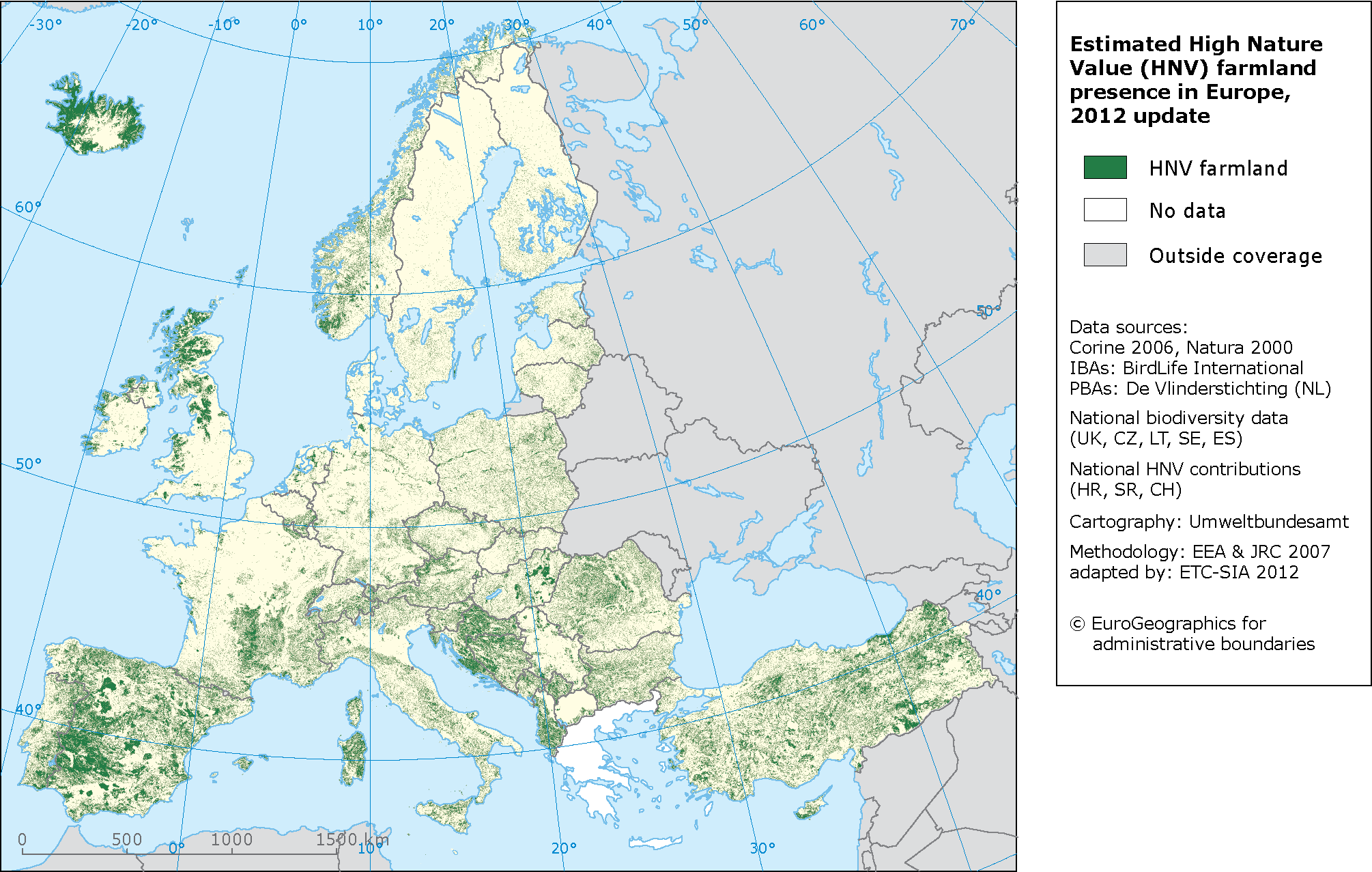
Estimated High Nature Value farmland presence in Europe which is characterised by a high proportion of semi-natural vegetation and low intensity agriculture, supporting rare species of European wildlife. Credit: EEA.
Estimated High Nature Value farmland presence in Europe which is characterised by a high proportion of semi-natural vegetation and low intensity agriculture, supporting rare species of European wildlife. Credit: EEA.
The European Union has raised concern about the threat of soil erosion, citing it as an indicator in the Climate change impacts and vulnerability in Europe 2012 report. Around 12 million hectares of EU agricultural land suffers from severe soil erosion, with an estimated loss of around 0.43% in crop productivity each year. While that may not sound like a lot, it adds up to an estimated loss of €1.25 billion worth of agricultural produce each year.

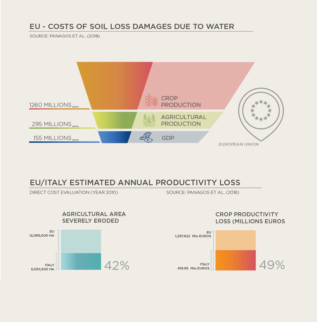
Cost of soil loss due to water erosion in the EU. Comparing agricultural land erosion and crop productivity loss in Europe and Italy. Credit: Panagos et al. 2018.
Cost of soil loss due to water erosion in the EU. Comparing agricultural land erosion and crop productivity loss in Europe and Italy. Credit: Panagos et al. 2018.
Italy is one of the most heavily impacted countries,
with water-induced soil erosion totalling
around €619 million per year.
Roughly a third of Italy’s agricultural area has been severely eroded, equivalent to around 41% of the total EU severely eroded agricultural area.
Climate projections indicate that more intense precipitation is likely be more frequent, exacerbating soil erosion. This releases the carbon stored within the soil, resulting in increased greenhouse gases in the atmosphere.
Such a feedback loop is expected to strengthen under high greenhouse gas emission scenarios, though some studies show that soil erosion could be reduced with the right policies.

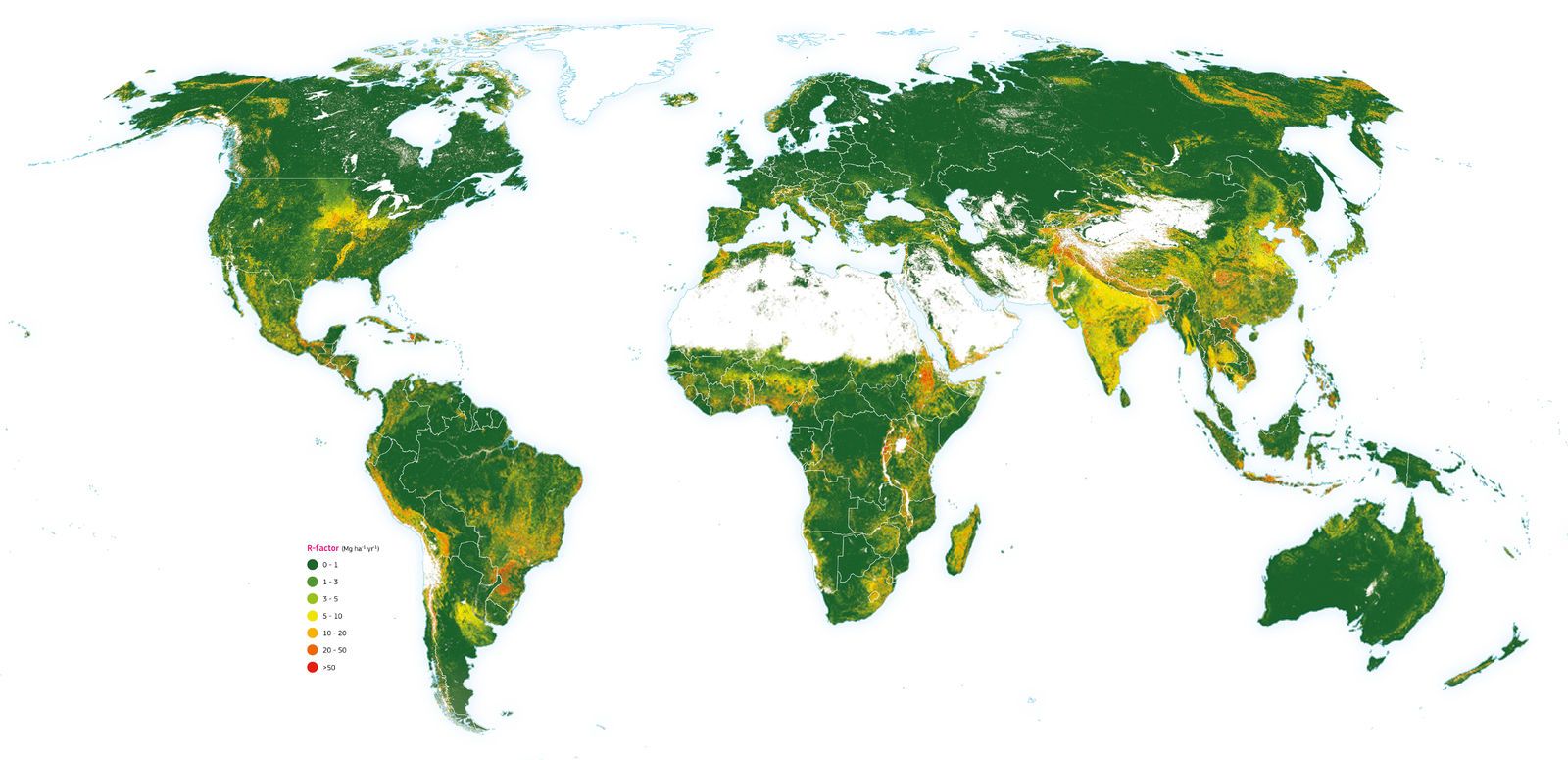
The map illustrates the soil erosion rates by water erosion divided into seven classes according to the European Soil Bureau classification. The colour gradation from green to red indicates the intensity of the predicted erosion rates. The baseline model predicts an annual average potential soil erosion amount of 35 Pg yr-1 for 2001, with an area-specific soil erosion average of 2.8 Mg ha-1 yr-1. In 2012, an overall increase of 2.5 % in soil erosion (35.9 Pg yr-1), driven by spatial changes of land use, was estimated. Being a global model, the map also covers areas where there is no direct anthropogenic impact. Credit: JRC.
The map illustrates the soil erosion rates by water erosion divided into seven classes according to the European Soil Bureau classification. The colour gradation from green to red indicates the intensity of the predicted erosion rates. The baseline model predicts an annual average potential soil erosion amount of 35 Pg yr-1 for 2001, with an area-specific soil erosion average of 2.8 Mg ha-1 yr-1. In 2012, an overall increase of 2.5 % in soil erosion (35.9 Pg yr-1), driven by spatial changes of land use, was estimated. Being a global model, the map also covers areas where there is no direct anthropogenic impact. Credit: JRC.
Intensive farming practices and climate change are predicted to increase the amount of soil erosion in the 21st century, as a result of farming runoff and intense precipitation events.
This erosion reduces the soil's ability to fight global warming. Soil acts as a carbon sink, taking in carbon dioxide from the atmosphere. A recent JRC-led study calculated that soil erosion on EU agricultural lands could lead to a 35% increase in liberated carbon in the period 2016–2100.
This additional carbon in the atmosphere will exacerbate global warming, as well as cause local environmental problems.

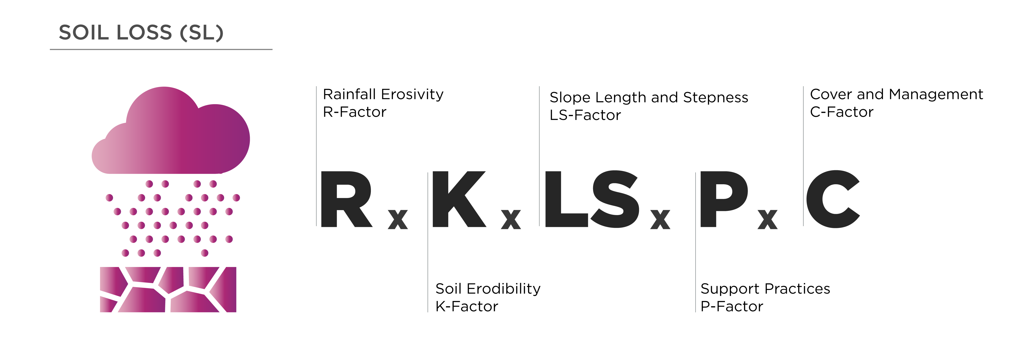
Soil loss can be calculated using the formula A=RKLSCP where A is computed soil loss, R is the rainfall-runoff erosivity factor, K is a soil erodibility factor, L is the slope length factor, S is the slope steepness factor, C is a cover management factor. Credit: CMCC.
Soil loss can be calculated using the formula A=RKLSCP where A is computed soil loss, R is the rainfall-runoff erosivity factor, K is a soil erodibility factor, L is the slope length factor, S is the slope steepness factor, C is a cover management factor. Credit: CMCC.

The full potential of the latest CDS datasets on rainfall is harnessed through C3S to provide input to the soil loss calculations. Credit: Copernicus Climate Change Service, ECMWF.
The full potential of the latest CDS datasets on rainfall is harnessed through C3S to provide input to the soil loss calculations. Credit: Copernicus Climate Change Service, ECMWF.
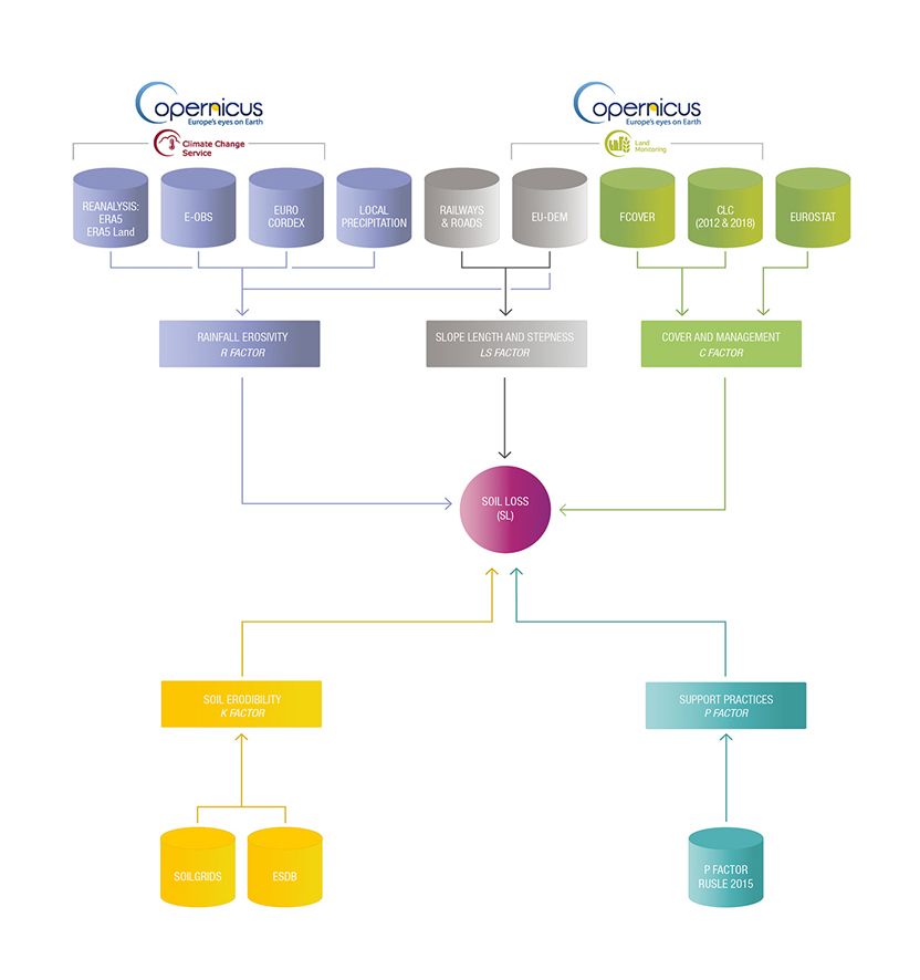
To build a tool capable of estimating water-induced soil erosion in Italy, CMCC integrated data from the C3S Climate Data Store with external datasets.
The tool uses a specialised empirical model known as the Revised Universal Soil Loss Equation (RUSLE). RUSLE combines information about the susceptibility of the soil to erosion with potential rainfall erosivity.
Finding the data – rainfall erosivity
Rainfall erosivity (the R-Factor) depends strongly on the severity and frequency of extreme precipitation events. Calculating the extent of rainfall erosivity using RUSLE requires detailed rainfall data, including on the frequency and severity of extreme precipitation events. CMCC used the latest CDS data on rainfall across Italy. Equipped with this information, it was possible to build up a picture of current and future soil loss.
The CDS hosts several observational datasets on rainfall, as well as data harnessed through C3S’s innovative reanalysis technique, which fills in gaps in spatial coverage to provide a more complete picture of the climate.
Past rainfall was calculated using the timeseries from observational dataset E-OBS and from the ERA5 and ERA5-Land reanalysis datasets, which have a horizontal resolution between ~31 km and ~9 km.
CMCC used the EURO-CORDEX regional climate simulations that include possible evolutions of future rainfall. These simulations, with a resolution of around 12 km, offer the possibility to project the potential evolution of rainfall erosivity under various future climate change scenarios.
The challenge: digging into the data
The rigorous calculation of the R-Factor – the measure of rainfall erosivity under the RUSLE model – needs high quality, granular data. This means information on rainfall at a sub-hourly level, with high geographical precision. Such high resolution data would enable a tool to account for variations in topography, such as mountains and hills, which can alter rainfall patterns on a local and wider scale.
Recent research has suggested that incorporating data with coarser time resolutions would enable the number of models used to calculate rainfall erosivity to be expanded. This approach was tested using data for Italy, and has been approved as a valid and reliable method by Italian regional authorities.
The solution: C3S data
CMCC used CDS rainfall datasets to calculate the R-Factor for regions across Italy.
The R-Factor was found to be higher in the west of Italy along the Tyrrhenian Sea, as well as over the Alpine and Apennine Mountains – areas where rainfall is abundant. On the other hand, it was found to be lower in the east of Italy along the Adriatic Sea, and over the major islands.
Besides the R-factor, six other indicators have been computed using the CDS rainfall datasets; these are considered by stakeholders to be proxies of rainfall erosivity.
Finding the data – soil susceptibility to erosion
Although soil is impacted by human activities, the factors that affect its actual susceptibility to erosion are thought to change beyond human timescales, over many centuries.
Above: Interactive map of rainfall erosivity (R factor, MJ mm ha-1 h-1 yr-1) calculated for the 1981–2010 reference period. Credit: ECMWF.
Pulling together the right people
The costs of soil erosion can affect agriculture directly through the loss of nutrients and the degradation of fertile land. Indirectly, the impacts can spread from farmland into nearby environments, as silt runs into reservoirs, and sediment enters fisheries, affecting marine life and fishery catches.
The wider impacts can extend to wildlife habitat destruction and biodiversity loss, both within the soil and in the habitats it serves to regulate. Natural hazards such as flooding can increase in frequency and severity due to soil erosion; this can impact infrastructure built on agricultural and natural lands.
To tackle the extensive task of using C3S data to assess and predict water-induced soil erosion, CMCC assembled a consortium of partners from institutions across the EU. Stakeholders invited to join the case study came from diverse sectors, including forestry, hydraulics, remote sensing, atmospheric sciences, agriculture, and environmental planning and support.
This collaboration between user groups is key to achieving the most from C3S data. Research networks such as CMCC can comprehensively process the high-quality data to make it more accessible to sectorial users.
Finding the right data through C3S
The extent of past, present and future data available through the CDS was a vital factor in developing the tool. C3S data is free to access and easy to use, and CMCC made use of data analysis tools available in the CDS Toolbox.
C3S data enabled CMCC to reach the levels of spatial and temporal resolution needed in this case study – in this case, detailed granular data across the Italian peninsula.
Image in Background: C3S Climate Data Store This image shows how to access data analysis tools in the C3S Climate Data Store Toolbox editor.
“By using the Climate Data Store and its Toolbox, we were able to assess soil loss at a regional scale, thanks to the high spatial and temporal resolution of the Copernicus Climate Change Service data.”
Monia Santini, CMCC
By combining rainfall data obtained through the CDS with external information on soil composition and distribution, CMCC created a new soil erosion dataset and several tools.
Through the case study, CMCC created a dataset of Soil erosion indicators for Italy, which contains fine-grained estimations of soil loss and rainfall erosivity across the country for 1981–2080. This high-resolution dataset helps stakeholders, environmental researchers and land managers assess and predict soil erosion for various territorial areas across Italy. CMCC also created an application that enables the visualisation of soil erosion indicators, soil loss and rainfall erosivity (R factor), for Italy.
The C3S Soil erosion explorer for Italy from 1981 to 2080, enables users to explore the data in the Soil erosion indicators for Italy dataset. The application provides estimates of rainfall erosivity and rainfall-induced soil loss across Italy, mapped for various projected climate change scenarios.
Changes in rainfall erosivity and soil loss vary largely between the regions, time horizons and climate scenarios. Under RCP8.5, on the farthest time horizon, decreases in rainfall erosivity and soil loss are estimated in the Southern part of Italy and large part of Sardinia (5%-15%). In contrast, the regions near the Adriatic Sea and Northern Italy (in particular Lombardia and Emilia Romagna) could experience increases of rainfall erosivity and soil loss of comparable magnitude.
The soil erosion explorer is particularly useful for users working in landscape management to make long-term assessments of how their decisions may impact the land, and to plan sustainable practices. Policymakers can use the application to understand how farming, forest management and even natural disaster recovery efforts can lower risks related to soil erosion, both physical and economic.
Building a sustainable future from the ground up
The soil erosion application and dataset could be adapted, tested and extended to countries around the world. This includes studying the R-Factor for different regions, and in-depth explorations into the susceptibility of soils around the world, depending on each country’s unique topology and soil composition.
Though Italy suffers from severe soil degradation, it is by no means the only region affected. The information gathered through the case study has great potential to help restore damaged soil around the world, and help repair a fundamental ecosystem that supports life, right beneath our feet.

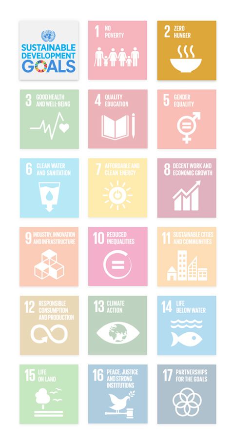

In working to maintain a healthy, sustainable soil landscape, this case study contributes to several of the UN Sustainable Development Goals (SDGs).
SDG 2: Zero hunger
Through SDG 2, the UN is working towards a world in which all forms of hunger and malnutrition are ended by 2030. This requires policies that create sustainable, healthy and productive agricultural sites around the world, particularly in poorer regions.
Though the case study focused on Italy, the application and dataset were created transparently under an internationally recognised empirical model. The information could help with soil and land management strategies elsewhere, and generally deepen our understanding of soil erosion under future climate change scenarios. By boosting sustainable soil management strategies, the case study contributes to SDG 2 and could help secure food for a growing global population.
SDG 6: Clean water and sanitation
Secure and sustainable sources of clean drinking water are becoming increasingly scarce in many regions of the world. Water stress, drought and desertification are all increasing as the climate changes. Protecting and restoring water-related ecosystems is deemed essential by the UN.
Healthy soils are critical to the Earth system, helping to regulate and clean water. Improving soil quality can contribute to a more balanced hydrological cycle and help reduce water stress. The developed application and dataset could assist in reversing soil erosion and preventing the future degradation of soils. This offers a contribution to SDG 6.
SDG 15: Life on land
Over 3.6 billion hectares of land around the world have turned to desert. This has drastically reduced the habitats of many species of plants and animals, contributing to the ongoing biodiversity crisis. The UN is calling for urgent action to protect vital ecosystems and create habitats to preserve biodiversity and maintain the world’s natural heritage.
Soil is a complex ecosystem unto itself, providing a habitat to an incredible number of unique and endemic species. Soil also helps to regulate other habitats, and ultimately provides the basis for land-based life to exist. By helping to preserve soil in Italy and beyond, the application is directly contributing to SDG 15.