A digital twin to sharpen our vision of extreme weather
All you need to know about DestinE's Weather-Induced Extremes Digital Twin

Back to ECMWF - Destination Earth main page
The Weather-Induced Extremes Digital Twin (Extremes DT) creates a unique capability to produce bespoke cutting-edge numerical simulations of extreme events on a timescale of a few days ahead, to support decision-makers to rapidly respond to meteorological, hydrological and air quality extremes as they emerge. It relies on a global component developed by ECMWF and on a regional component developed by a strong partnership led by Météo-France. The global component will be run on a regular basis, while the regional component will be activated to zoom in on extreme events occurring over Europe.
The ambitious Destination Earth (DestinE) initiative of the European Union aims at building a digital replica - or twin - of the Earth system in support of the EU Commission’s Green Deal environmental policies and of the Digital Strategy. DestinE will allow us to better respond and adapt to the environmental challenges posed by climate change and extreme events, by creating a new type of information system, characterized by enhanced quality and interactivity.
With weather-induced extreme events becoming more frequent and intense in a changing climate, it becomes urgent to boost our abilities to anticipate their impacts and support decision-makers to rapidly take action and prevent the worst consequences. This is why one of the first two high-priority digital twins developed in DestinE focuses on weather-induced extremes.
The Weather-Induced Extremes Digital Twin (Extremes DT) will support decision-makers to rapidly respond to extreme events as they emerge, through its unique bespoke simulation capability that allows to zoom in on meteorological, hydrological and air quality extremes as they emerge. It relies on cutting-edge very high-resolution numerical simulations on a timescale of a few days ahead, which makes it possible to provide detailed information at the scales where extreme events matter and are felt, with a focus on the sectors most impacted by climate change. The Extremes DT thus complements existing weather and impact sector prediction capabilities, at national and European levels.
The Extremes DT exploits decades of investment in earth-system prediction capabilities and observations, the latest breakthroughs in artificial intelligence and digital technologies and Europe’s leading supercomputers, those of the EuroHPC Joint Undertaking.

The first official MTG-FCI visible image from EUMETSAT (left) and 12-hour simulation with ECMWF’s Integrated Forecasting System (IFS) at 2.8 km resolution (right), valid for 18 March 2023 at 12:00 UTC. Credit: EUMETSAT/ECMWF
The first official MTG-FCI visible image from EUMETSAT (left) and 12-hour simulation with ECMWF’s Integrated Forecasting System (IFS) at 2.8 km resolution (right), valid for 18 March 2023 at 12:00 UTC. Credit: EUMETSAT/ECMWF
The Extremes DT is implemented by the European Centre for Medium-Range Weather Forecasts (ECMWF) together with many partners throughout Europe. ECMWF is also responsible for delivering the second high-priority digital twin in DestinE on Climate Change Adaptation (Climate DT), as well as the Digital Twin Engine (DTE). This complex software infrastructure will enable the running of not just the first two high priority twins but also integrate or support interoperability with other Digital Twins as they are developed. The DTE will also enable the handling of the vast amounts of data generated from the DestinE Digital Twins and tailor it to the user's needs.
The Digital Twin for Weather-Induced Extremes
ECMWF is building the global component of the Extremes DT, which will be executed in a continuous production mode, with simulations performed regularly (starting with a few times per week) on the EuroHPC facilities (LUMI in Finland and Leonardo in Italy). This global component will rely on an enhanced earth-system simulations-observations fusion, and on simulations performed with ECMWF Integrated Forecasting System (IFS) at km-scale resolution (2 to 4km) for four days ahead. In parallel, Météo-France and a consortium involving many meteorological services and academic institutions throughout Europe are developing the on-demand production mode of the Extremes DT. This component will rely on a configurable and interactive framework which can be activated as extreme events occur over Europe, allowing to zoom in and assess the impacts of weather-induced extremes at sub-kilometre scale resolutions on a timescale of a couple of days ahead.
“With Destination Earth, the European Commission is giving a decisive push to create a new type of information system that will allow to better respond and adapt to the pressing challenges of climate change and extreme events. DestinE will greatly complement the existing capabilities provided by national or European initiatives, such as for example the national meteorological services or EU’s Copernicus services. By doing so, it will benefit decision makers in Europe supporting the implementation of the twin transition – green and digital. All the scientists involved in the Extremes DT are understandably enthusiastic about the huge potential of the bespoke cutting-edge Earth system simulation capabilities we are building in DestinE.”
Irina Sandu, Director for Destination Earth at ECMWF.
Global Extremes DT: a magnifying glass for extreme weather
The global, continuous component, of the Extremes DT will deliver a powerful tool to anticipate the impacts of extremes and help to inform decision making by relevant national authorities to ensure the safety of lives and property.
The global component of the Extremes DT will provide simulations at km-scale, and typically a spatial resolution between 2 km and 4 km for atmosphere and land and during the initial phases, coupling with waves, ocean and sea ice.
Four-day long simulations will be initialized daily from the best possible initial conditions – or estimates of the state of the atmosphere, land and ocean. This is possible thanks to optimised data fusion and data assimilation approaches, ingesting for example Earth-system observations at increasingly higher spatial and temporal scales.
The global component of the Extremes DT will also integrate selected impact sector elements such as hydrology and atmospheric composition. These elements will be integrated at the same fine scales as the atmosphere and land components to provide a global prediction capability providing decision-making support, from global to local scales to assess meteorological, hydrological and air quality extremes timely and at a qualitatively new level.
From increased resolution to better simulations
While increasing the resolution of simulations can appear to be simple, provided that we have the necessary computing capacity, the finer resolution ‘per se’ doesn’t automatically guarantee better simulations and more accurate predictions.
“As we increase the spatial resolution, we also need to reduce the model time step to better resolve phenomena in time, and to ensure numerical stability. However, certain schemes governing dynamics and parameterizations depend on the model time-step and get impacted when reducing the time-step and need to be adapted. Furthermore, as we reach finer resolution, at which some of the processes become partly directly resolved, some of the assumptions underpinning the model parameterizations are no longer valid and this needs to be reconsidered carefully.” said ECMWF scientist Benoît Vannière, who coordinates the global Extremes DT simulations.
Watch: The Weather-Induced Extremes Digital Twin, Benoît Vannière
Improving the quality of km-scale simulations demands a careful adaptation of many of the parameters involved and it is one of the priorities for ECMWF together with its partners in DestinE.
Firstly, the IFS Earth-system model itself must be carefully adapted to provide the improved quality expected from the Extremes DT simulations at km-scale resolutions. Increasing the resolution of simulations requires adapting the dynamics and physics equations and parametrizations of the Earth-system processes as well as the data assimilation and observation methodologies to create better initial conditions.
In addition, the teams involved in DestinE at ECMWF are working on the integration of impact-sector elements to the Earth system model, on adapting the IFS code and infrastructure to run efficiently on a wide variety of extreme scale computing systems with different technologies and on developing methodologies for uncertainty quantification of the global Extremes DT. Machine learning and artificial intelligence approaches will increasingly be used in the Extremes DT, in particular for enhancing the uncertainty quantification of the simulations by using data-driven models such as the ECMWF AIFS.
Encouraging first demonstrations
For the first steps towards developing the global component of the Extremes DT, ECMWF has run 5 days simulations at 4.4 km for a selection of past extreme events or events arising during 2022 and 2023.
The team then ran 5-10 day simulations at 4.4 km resolution, initialized daily over past periods of several months. In addition, since August 2023, 5 days simulations at 4.4km are run daily on ECMWF Atos supercomputer.
For certain extreme events, simulations were also carried out at 2.8km to explore the benefits of further enhancements of the horizontal resolution.
After porting the global Extremes DT workflow on the LUMI supercomputer in Finland and adapting the IFS to its mixed architecture containing AMD GPUs, 4.4km pilot simulations are also run on LUMI on a regular basis since December 2023.
The first results of the global Extremes DT simulations, presented at several scientific conferences, are encouraging.
“There are many adjustments to be made in the model and workflows to run in the heterogeneous EuroHPC systems, but we are moving forward at good pace and the simulations are very encouraging. The entire team is working very hard to produce and analyze these initial simulations at high resolution for extreme case studies, and investigating the model developments that need to be made to improve the simulations at those horizontal resolutions. The first results are promising, we already demonstrated improvements forecasting hurricane intensities, medicanes and precipitation in complex orographic areas.”
Estibaliz Gascón, scientist at ECMWF involved in the Extremes DT.
For example, our team could demonstrate the benefit of representing smaller scales in global weather forecasts at 4.4km resolutions. With current ECMWF operational forecasts at 9 km spatial resolution, the extreme wind speeds would have been underestimated before hurricane Idalia made landfall above Florida, while DestinE simulation provided more realistic conditions a few days ahead. Correctly predicting tropical cyclones in the North Atlantic is very important for capturing the weather situations over Europe a few days later.

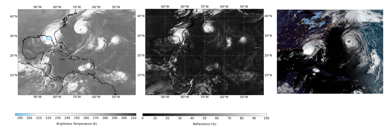
The simulated infrared brightness temperature for a 36-hour forecast at a 4.4 km resolution initialized on August 28th (left) with corresponding visible reflectance (center) captures the deep convective clouds of hurricane Idalia during landfall, as well as the eye structure of hurricane Franklin. Satellite observations in the early morning hours (right) show the spiraling cloud bands of hurricane Franklin with the eye structure, just two hours before Idalia makes landfall.
The simulated infrared brightness temperature for a 36-hour forecast at a 4.4 km resolution initialized on August 28th (left) with corresponding visible reflectance (center) captures the deep convective clouds of hurricane Idalia during landfall, as well as the eye structure of hurricane Franklin. Satellite observations in the early morning hours (right) show the spiraling cloud bands of hurricane Franklin with the eye structure, just two hours before Idalia makes landfall.
The first tests towards the scales of the global Extremes DT have also been proven to better predict maximum peaks of precipitation in orographic environments such as the Alps. The tests at 4.4 and 2.8 km progressively represented more accurately the extreme precipitation over the Alps than the current operational simulations (9 km), not only for individual storms like storm Alex (2020), but also for a series of extreme events, and more generally for winter periods.

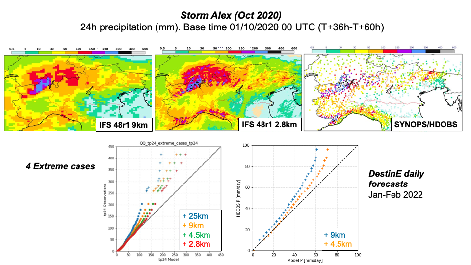
Top row, left to right: 24h accumulated precipitation predicted by a 9km and 2.8km IFS forecasts between leadtimes 36h and 60h and compared against rain gauge measurements. Bottom left: quantile-quantile distribution of 24h accumulated precipitation (accumulated between T+48h and T+72h) for IFS forecasts at four resolutions (25, 9, 4.5 and 2.8 km) against SYNOP rain gauges for four extreme precipitation events. Bottom right: quantile-quantile distribution of 24h accumulated precipitation (accumulated between T+48h and T+72h) for IFS forecasts at two resolutions (9 and 4.5 km) against SYNOP rain gauges for two-months of daily initialized forecasts.
Top row, left to right: 24h accumulated precipitation predicted by a 9km and 2.8km IFS forecasts between leadtimes 36h and 60h and compared against rain gauge measurements. Bottom left: quantile-quantile distribution of 24h accumulated precipitation (accumulated between T+48h and T+72h) for IFS forecasts at four resolutions (25, 9, 4.5 and 2.8 km) against SYNOP rain gauges for four extreme precipitation events. Bottom right: quantile-quantile distribution of 24h accumulated precipitation (accumulated between T+48h and T+72h) for IFS forecasts at two resolutions (9 and 4.5 km) against SYNOP rain gauges for two-months of daily initialized forecasts.
With these encouraging tests in sight, all the teams are now focused on the next step which consists in transitioning the global Extremes DT towards an operational-level execution on the EuroHPC systems (initially LUMI, then Leonardo) in phase 2 of DestinE, and on continuing to improve the quality of the simulations and their uncertainty quantification.
On-demand Extremes DT: gathering European excellence
Météo-France leads the implementation of the on-demand component of the Extremes DT on behalf of ECMWF. The on-demand Extremes DT, developed by a wide European consortium involving some of the leading national meteorological and research centres, will provide a cutting-edge bespoke simulation capability for predicting environmental extremes at sub-kilometre scales on a timescale of a couple of days ahead. The on-demand Extremes DT will be activated when certain extreme events are detected using information from the global component of the Extremes DT. It will allow to zoom in on extreme events happening over Europe, tailoring the information stream to better support decision-making and the sectors impacted. For example. For example, it will allow meteorologists to track a winter storm as it moves over Europe or to zoom in on a strong air pollution event in a certain region.
The teams involved have already set up a workflow based on the ACCORD* numerical weather prediction system. The system is initialized using regional analysis, or ECMWF operational analysis. For now, it uses information from ECMWF operational forecasts for the lateral boundary conditions, but later on it will use information from the global component of the Extremes DT.
The first experiments have shown improved performances at horizontal resolutions of 500 m compared to the operational forecasts at 2.5 km for some of the tested weather extremes situations.
The map below shows the added value of simulations at 500 m compared to the operational resolution for a record-breaking static convective storm in the Spanish region of Valencia on 3 May 2022. This is a typical example of a convective storm that the current operational models couldn’t predict correctly.

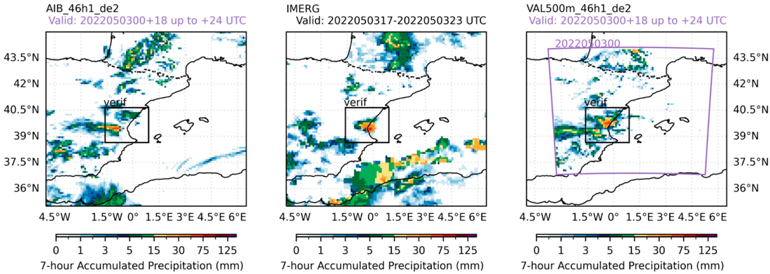
The 500 m resolution run (right) captures better the stationary precipitation band observed by the IMERG satellite (center) than the 2.5 km operational run (left). Credit: Destination Earth On-Demand Extremes Digital Twin team. Find out more on this poster presented at the 2nd DestinE User eXchange.
The 500 m resolution run (right) captures better the stationary precipitation band observed by the IMERG satellite (center) than the 2.5 km operational run (left). Credit: Destination Earth On-Demand Extremes Digital Twin team. Find out more on this poster presented at the 2nd DestinE User eXchange.
The On-Demand Extremes DT scientists are also fine tuning the detection of extreme events and the activation of the On-Demand capability to find the best setup, considering factors such as technical readiness, type of extremes, adequate model set-up, potential added values, cost efficiency among others. The objective is also a transition towards an operational-level execution on the EuroHPC systems during Phase 2 of Destination Earth.
The use cases for hydrology, air quality and renewable energy in the framework of this partnership led by Meteo-France are already set in motion, contributing to adapt the On Demand DT workflow to the requirements of the impact sector.
Thanks to both components of the Weather-Induced Extremes Digital Twin of Destination Earth, the global continuous and the on-demand regional capabilities, which complement existing national and European prediction capabilities, Europe will be better equipped for anticipating and analysing extreme weather events at the global and regional scales.
*ACCORD: A Consortium for COnvection-scale modelling Research and Development, formed by 26 Euro-Mediterranean National Meteorological Services.
Destination Earth is a European Union funded initiative launched in 2022, with the aim to build a digital replica of the Earth system by 2030. The initiative is being jointly implemented by three entrusted entities: the European Centre for Medium-Range Weather Forecasts (ECMWF) responsible for the creation of the first two ‘digital twins’ and the ‘Digital Twin Engine’, the European Space Agency (ESA) responsible for building the ‘Core Service Platform’, and the European Organisation for the Exploitation of Meteorological Satellites (EUMETSAT), responsible for the creation of the ‘Data Lake’.
We acknowledge the EuroHPC Joint Undertaking for awarding this project strategic access to the EuroHPC supercomputers LUMI, hosted by CSC (Finland) and the LUMI consortium, Marenostrum5, hosted by BSC (Spain) Leonardo, hosted by Cineca (Italy) and MeluXina, hosted by LuxProvide (Luxembourg) through a EuroHPC Special Access call.
More information about Destination Earth is on the Destination Earth website and the EU Commission website.
For more information about ECMWF’s role visit ecmwf.int/DestinE
For any questions related to the role of ECMWF in Destination Earth, please use the following email links:
Press and Communications enquiries
Main picture: iStock